


.jpg)
About 30km drive from Hoa Binh will lead to a rest house named Kim Boi. The house was built near a large mineral water pool. Visitors sitting inside the house can hear the sound of the water, which is at a constant temperature of 36ºC, continuously spouting out. Scientific tests have shown...
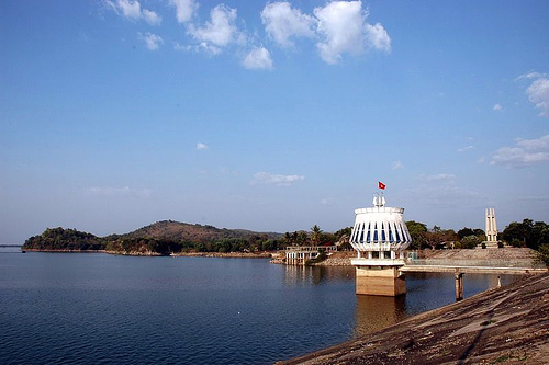
Dau Tieng Lake is a borderless body of water built by Tay Ninh people. With a total area of 27,000 ha and a total volume of 1.5 billion m3, the lake is not only capable of providing water for the province’s agriculture but it is also one of the most visited tourism sites in the country.Dau...
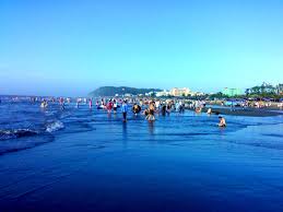
Sam Son is a coastal borough in the east of Thanh Hoa, 16km from the center of Thanh Hoa City. This place has been a famous spot for tourism in Vietnam since the beginning of the previous century, when the French begun to build facilities there to serve themselves and the courts of the Nguyen...
.jpg)
Langbian Mountain is located in Lac Duong district which is 12 km from Dalat in the North. With its height of 2,169m above the sea level, Langbian Mountain has not only been an attractive tourist site but also kept a legend about a passionate love. According to the old people, there was a love...
Colline de 986 m émergeant de la plaine. Depuis la nuit des temps, la montagne fut un sanctuaire pour les différents peuples de la région : Khmers, Cham, Vietnamiens... Du fait de la " disneylandisation " du lieu, il a aujourd'hui beaucoup perdu de son aura...
.jpg)
Ham Rong se trouve à proximité de la ville de Sapa, à 3 km, les visiteurs peuvent y aller à pied. Restez sur le sommet Ham Rong, vous aurez une vue panoramique de Sapa, la vallée de Muong Hoa, Sa Pả, Tả Phìn cachés dans le brouillard....
Approximately 70 kilometers southwest of Ha Noi, Huong Son boasts quite a few pagodas built in the Posterior Le Dynasty. Until the beginning of the 20th century, there have over 100 pagodas. Visitors can go to Huong Son via the Ha Dong - Van Dinh route.Vietnamese or foreigners alike wish to come...
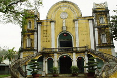
L’église de Tra Kieu se situe au village de Tra Kieu, commune de Duy Son, district de Duy Xuyen,province de Quang Nam. Elle est à 37km au Sud de Da Nang. Elle s’élève sur le terrain de l’ancienne citadelle de Tra Kiêu. Cette...
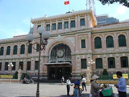
La poste centrale (Buu Dien) constitue un témoignage important de l'architecture française au Vietnam, ce qui explique sa position de monument incontournable d'Ho Chi Minh-Ville.Fondée entre 1886 et 1891, ce bel immeuble rappelle les constructions parisiennes. Ainsi,...
Soc Trang Clay Pagoda is situated at the heart of the city, with the more formal name Buu Son Tu. From the outside, the pagoda resembles more of a resident house than a pagoda, without any pillar or wooden panel like typical pagoda architecture.Like the Stork Garden of Tan Long, Clay Pagoda...

Soyez le premier à connaître nos offres de voyage exclusives et les nouveaux circuits !.


 Langue