


 With an area of 56,200 ha, Phu Quoc is the largest in an archipelago of 14 islands. Phu Quoc island lies in the Gulf of Thailand, about 40 km due west of the Vietnamese mainland. Phu Quoc National Park is situated in the north-east of the island, and the northern and eastern boundaries of the national park follow the coastline. The topography of the national park is hilly, although not particularly steep. The highest point in the national park is Mount Chua at 603 m. The national park is drained by numerous, mainly seasonal, streams. The only sizeable river on the island is the Rach Cua Can river, which drains the southern part of the national park, and flows into the sea on the west coast of the island.
.jpg)
Phu Quoc, the largest island in Vietnam, is also part of an archipelago consisting of 22 islands and islets. The island covers an area of 585km2 and is 50km long.Phu Quoc is called the island of "99 mountains" because of its many sandstone chains gradually descending from the north to the south....
.jpg)
U Minh Thuong National Park is located in An Minh Bac commune of An Minh district, and Minh Thuan commune of Vinh Thuan district, Kien Giang province, 365 km south-west of Ho Chi Minh City. U Minh Thuong National Park covers an area of 21,107 ha, which core area accounts for 8038 ha, and buffer...
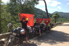
Riding motorbikeHire motorbike on your own and explore the northerly parts of the island. The best areas and most forested parts can be found on the road toward Ganh Dau. To get there, take the road from Duong Dong towards Bai Thom and turn off toward Ganh Dau, the National park becomes more...
.jpg)
Ha Tien is a seaside and fishing resort which offers several beautiful and interesting sites to discover.People visit Ha Tien hoping to capture the magic of the land in South Vietnam, where many heroic historical places such as imperial tombs and ancient pagodas can be visited. Ha Tien is such a...

Soyez le premier à connaître nos offres de voyage exclusives et les nouveaux circuits !.


 Langue