


Le parc national de Tam Dao ou parc national de Tam Đảo (Vườn quốc gia Tam Đảo) est un parc national situé sur le massif de Tam Dao - Trois monts sur les provinces de Vĩnh Phúc, Tuyen Quang and Thai Nguyen au Viêt Nam. La chaîne de montagne est composée d'une vingtaine de pics de plus de 1 000 mètres d'altitude. Elle abrite une faune et une flore riche de 2 000 espèces de plantes et 840 espèces d'animaux2. Malgré la protection du site, le parc a souffert de l'abattage illégal et du braconnage, toutefois des espèces rares d'oiseaux, de camélia et d'orchidées y sont encore observables.

Le parc a été créé en 19964 à partir du Conservation Forest Tam Dao fondée en 19771. Il est situé à 80 km de Hanoï et est un site connu de villégiature.
.jpg)
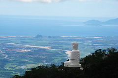
Located in north-east of Quang Ngai Province, about 15 nautical miles (27km) from mainland. Ly Son Island holds an important strategic position in the East Sea of Viet Nam and contains diversified tourism potential and valuable documents on Hoang Sa (Paracel) Archipelago.With an area of...
.jpg)
Vinh Moc Tunnels - a place well-known as an underground village constructed to avoid bombardments during the American War (1965-1966). The spectacular tunnel network stands as a testament to the endurance, wisdom and bravery of the local people in their fight for independence. The tunnels used to...
.jpg)
The architectural significance of Hoi An has been recognized by UNESCO, during the 23rd Congress which took place in Marrakech (Morocco) from the 29th of November to the 4th of December, since the town was officially listed as a World Heritage Site.After a long period of absence from the tourist...
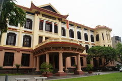
Just across the street from the Temple of Literature, Vietnam Fine Arts Museum can be easily spottedfrom afar. Like many other buildings that house museums in Hanoi, it was built in the 1930s as a Girl School for Indochina high-ranked officers. In 1966, it officially became Vietnam Fine Arts...
.jpg)
Dong Ho Village with its famous paintings has become an aesthetic symbol in Vietnam culture. Located to the left side of Duong River, Dong Ho stood for centuries making their unique art work. From over 100 families in the 1950s, currently there are only a handful of families still making the...
Bà Nà Hills a devancé de nombreux candidats pour remporter cette distinction. Grâce à l'exploitation de ses potentiels touristiques, le site apporte une contribution notable au développement de la ville de Dà Nang (Centre) et de la Route...
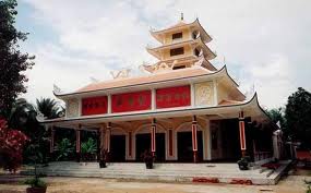
Tuyen Linh Temple was built from bamboo in 1861 near the Tan Huong channel in Minh Duc, Mo Cay, Ben Tre. The temple was firstly named Tien Linh, and led by Abbot Khanh Phong. In 1907, a monk name Le Khanh Hoa, an expert in Buddhism, was appointed to lead the temple and then in...
.jpg)
The City Bird Garden is situated inside the Cultural Park, also known as Lam Vien May 19th Park, in Ca Mau City. Only 2km away to the West of the center of the city, this garden is the place where many precious types of bird reside and gather every year. The Cultural Park covers a total area...
.jpg)
Yok Don National Park, the largest of Vietnam’s nature reserves, has been gradually expanded and today encompasses 115,545 hectares of mainly dry deciduous forest. The park runs all the way up to the border with Cambodia, with the beautiful Srepok River flowing through it.Yok Don is home to...

Soyez le premier à connaître nos offres de voyage exclusives et les nouveaux circuits !.


 Langue
.jpg)